
By SDCN Editor
Sacramento, CA–With Tropical Storm Hilary forecasted to be the wettest tropical cyclone in state history and the first-ever Tropical Storm Watch issued for California, the state is mobilizing to protect people from the storm and reminding everyone in the storm’s path to take steps now to prepare.
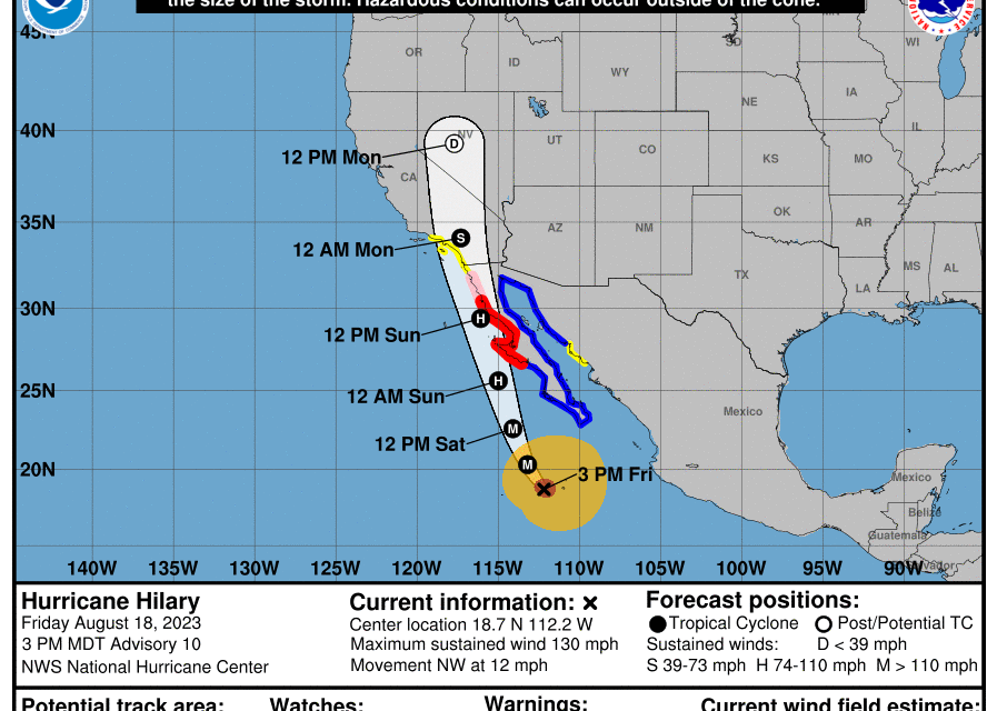
Hilary – currently a powerful Category 4 storm – is forecast to track into the state over the weekend and into early next week, bringing moderate to heavy showers, thunderstorms, and possibly stronger winds. Some parts of Southern California could receive a year’s worth of rain from this storm. The location and intensity of precipitation and winds will be variable as the storm approaches the state.
“We should never underestimate the power of Mother Nature. California is coordinating with federal and local governments to support communities as they prepare for this unprecedented storm. Heed warnings from local authorities, be ready, and stay informed, Gov. Newsom said”
The governor is headed to Southern California and will be there for the next several days as the storm makes landfall.
At the direction of Governor Newsom, the State Operations Center at the Governor’s Office of Emergency Services (Cal OES) is currently activated and the state is closely monitoring incoming impacts from rain, wind, and potential flash flooding and power outages. The State Operations Center is actively coordinating across state agencies to provide resources in preparation for potential impacts and to support response and recovery efforts.
In coordination with locals, the state is prepositioning resources including swift water rescue teams, California National Guard teams, and flood fighting tools while also working closely with community-based organizations to protect vulnerable unhoused people. Additionally, California is staffing highway maintenance crews 24 hours a day and taking proactive steps to maintain roadway safety.
Californians are reminded to dial 3-1-1 to get help or ask questions. If they have a critical emergency, call 911. Stay informed by signing up for emergency alerts including warnings and evacuation notices. Visit CalAlerts.org to sign up to receive alerts from county officials. Check in with loved ones and neighbors.
Before a high wind event occurs, residents should remove any dead trees or overhanging branches near structures, remove loose roofing material, bring in unsecured objects from patios and balconies, secure outdoor objects that could blow away, shutter windows securely, and brace outside doors.
During a high wind event, individuals are advised to take cover next to a building or under a shelter, stay away from windows, stay clear of roadways and train tracks, avoid elevated areas such as roofs, and watch for flying debris.
The National Weather Service has issued a high surf advisory and is urging beachgoers to stay out of the ocean as the storm will create strong breaking waves, shore breaks, and strong longshore and rip currents, making the ocean extremely dangerous.
Avoid non-essential travel during the peak of the storm expected Sunday and Monday. Anyone who must drive, download the QuickMap app, or visit QuickMap (ca.gov) to learn up-to-the-minute information on road conditions, traffic, closures, and more. Do not walk, swim or drive through flood waters. Turn Around, Don’t Drown! Remember, just six inches of moving water can knock you down, and one foot of moving water can sweep your vehicle away.
Be ready in case of power outages. Take inventory of the items you need that rely on electricity. Keep your devices charged. Plan for batteries and other alternative power sources to meet your needs if the power goes out such as a portable charger or power bank. Have flashlights for every household member. Also, plan accordingly for the potential of water outages.
Listen to local authorities. Always follow the guidance of your local authorities, including evacuation orders, road closures, and other official notices.